
Granite Moccasin Project: Public Review & Comment Period
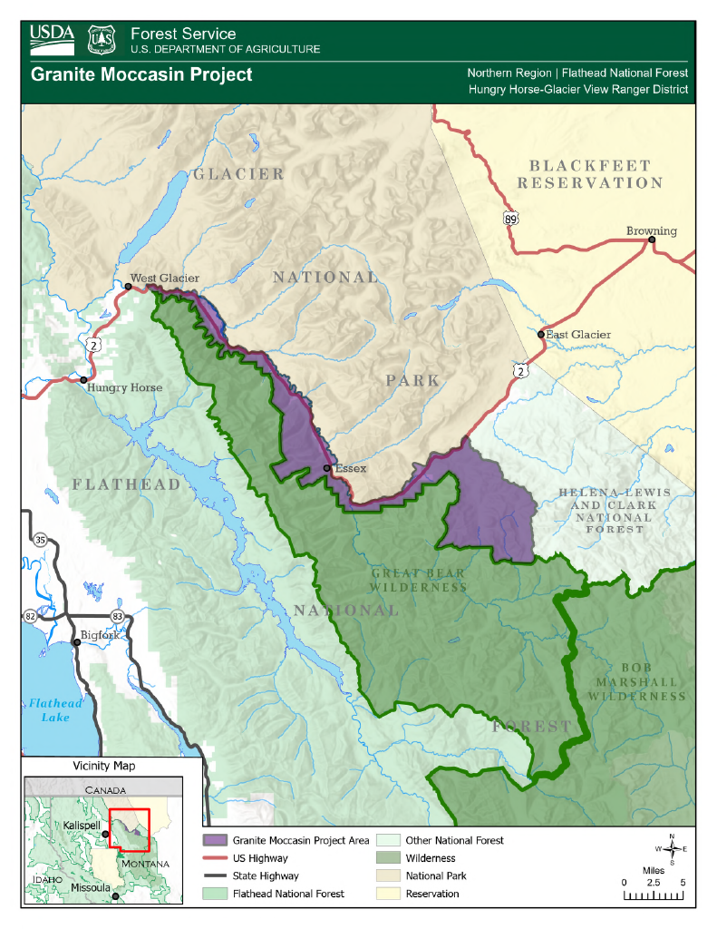
The Hungry Horse Ranger District of the Flathead National Forest has released the proposed Granite Moccasin Project (#68919), a 67,536-acre project located south of Glacier National Park in Flathead County and spanning roughly 40 miles along U.S. Highway 2. The proposal includes commercial and noncommercial forest treatments, road management, fuels reduction, and whitebark pine restoration intended to reduce wildfire risk and support forest health and resilience. The project area includes recommended wilderness, inventoried roadless areas, and designated Flathead Wild and Scenic River corridor. Public is encouraged to review the full proposed action, project maps, and supporting documents and submit comments by January 15, 2026 at 11:59:59 PM (MST) to Flathead National Forest. Below are some excerpts from Proposed Action.
Treatment in Wild and Scenic River Corridors
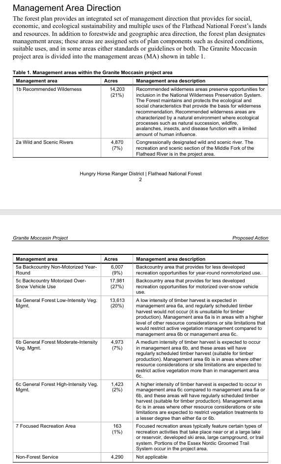
In 1976, Congress designated the North, Middle, and South Forks of the Flathead River as part of the National Wild and Scenic Rivers System. Wild and scenic rivers are designated for their free-flowing character and natural, cultural, or recreational values. The project area includes the section of the Middle Fork of the Flathead River classified as recreational and assigned management area 2a under the forest plan. The Middle Fork of the Flathead River scenic section has outstandingly remarkable values for fisheries, geology water quality, wildlife, recreation, scenery, history, and ethnography. Recreation river corridors are not suitable for timber production; however, timber harvesting for other multiple-use purposes and to achieve desired vegetation conditions can occur (MA2a-SUIT-02). Actions are proposed on about 402 acres in wild and scenic river corridors, which includes about 102 acres of utility corridor expansion.
Treatment in Recommended Wilderness: Proposed activities in Rec Wilderness include up to 682 acres of whitebark pine (WBP) planting using hodad (a planting tool). *site conditions and logistics-dependent, no mechanical work as per the forest plan
Treatment in Old Growth: While there are approximately 4,620 acres of old growth within the project area, only 42 acres are proposed for treatment. This treatment is limited to a single stand experiencing widespread mortality.
Treatment in Inventoried Roadless Area
Vegetation management is proposed on up to 2,250 acres in roadless areas, including prescribed fire, commercial thinning, noncommercial thinning, and white bark pine restoration treatments. No road construction would occur in roadless areas to accomplish these activities. These activities will be consistent with the 2001 Roadless Conservation Rule.
Of the approximately 2,250 acres of proposed treatment in Roadless areas:
- 1,600 acres are planned for whitebark pine restoration, including noncommercial thinning, prescribed burning, and planting;
- 240 acres involve prescribed burning only; and
- 350 acres include commercial thinning, with about 60 acres of pre-commercial thinning and understory work.
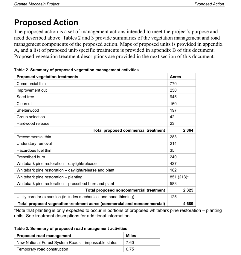
U.S. Department of Agriculture, Forest Service. Granite Moccasin Project: Proposed Action. Publisher, 2025, https://www.fs.usda.gov/r01/flathead/projects/68919. Northern Region | Flathead National Forest, Hungry Horse Ranger District. Proposed Action Plan for the Flathead National Forest.
FLATHEAD NATIONAL FOREST GRANITE MOCCASIN PROJECT WEBPAGE
FLATHEAD NATIONAL FOREST PROPOSED ACTION + DETAILED MAPS
The Forest Service has asked for feedback on the Proposed Action. Public comments are requested by January 15th, 2026 11:59:59 PM (MST).The proposed action can be accessed at the project web page: Flathead National Forest | Project Summary (#68919) | Forest Service (www.fs.usda.gov/r01/flathead/projects/68919)
Get Connected
Robert Davies
10 Hungry Horse Drive
Hungry Horse, MT 59919
406-387-3801
robert.davies@usda.gov
Submit Comments Electronically
Comments including attachments may be submitted electronically at
US Forest Service NEPA Projects Home
https://cara.fs2c.usda.gov/Public/CommentInput?Project=68919. Acceptable formats include MS Word, RTF, or PDF.

Flathead National Forest Project Page:
www.fs.usda.gov/r01/flathead/projects/68919
Flathead Wild & Scenic River 101 Webinars: http://www.flatheadrivers.org/…/flathead-wild-scenic…
LEARN MORE ABOUT FLATHEAD RIVERS ALLIANCE
Flathead Rivers Alliance is a nonprofit organization formed in 2019 dedicated to safeguarding the future of the Flathead River system together. The Three Forks of the Flathead River are 219 miles of nationally designated Wild and Scenic River and the inspiration behind the 1968 National Wild & Scenic Rivers Act. The river system flows through the traditional homelands of the Ktunaxa, Kootenai, and Séliš (Salish) Peoples who have long stewarded this landscape and the Pikuni (Blackfeet) Peoples who often traveled in the river corridor. The Three Forks of the Flathead Wild and Scenic River is administered by the Flathead National Forest with portions cooperatively managed with Glacier National Park and Montana Fish, Wildlife and Parks.